GNSS Positioning vs Satellite Communication in Cold Chain Tracking (and What “BeiDou” Really Means)
This article complements the GPT29 Cold Chain White Paper.
Download the PDF: GPT29 Cold Chain Tracking for Freezers — Engineering & Compliance White Paper
Why this confusion matters (operations expectations)
Overseas cold chain teams often ask: “Are you using BeiDou or a foreign satellite system?” The question mixes two separate concerns:
- How the device computes location (positioning satellites = GNSS).
- How the device sends data to your platform (communications networks = cellular IoT or satellite comm).
When these are conflated, expectations become unrealistic—especially on ocean routes where cellular coverage can be limited. The engineering solution is to plan for what the route can actually support: near real-time where coverage exists, and buffered continuity where it doesn’t.
GNSS 101: what “multi-constellation” means
GNSS (Global Navigation Satellite System) is an umbrella term for satellite constellations used to compute position. Common constellations include GPS (US), Galileo (EU), GLONASS (Russia), and BeiDou (China).
Key point: whether a device supports a specific constellation depends on the GNSS module configuration. “BeiDou support” is a positioning capability, not a data transmission method.
Satellite communication: a different network layer (and a different cost profile)
Satellite communication refers to transmitting data through a satellite network (not just computing location). Compared with cellular IoT, satellite comm typically involves different hardware, different service contracts, and a different power/cost profile.
Many overseas cold chain programs do not require satellite communication if their operational need is: audit-ready continuity rather than second-by-second live tracking during the entire ocean leg. In such cases, buffering + replay can deliver a coherent timeline for investigations and compliance.
What to expect on ocean legs: plan for offline windows
On ocean routes, cellular coverage can be intermittent or absent depending on distance from shore and network conditions. A realistic expectation framework is:
- Near real-time updates are achievable in covered areas (near shore, inland legs, many terminals).
- Offline windows are expected during certain segments (long open-ocean legs, shielded storage zones).
- Continuity is achieved via on-device buffering and resend/replay after reconnection.
Deep dive on continuity controls: Cold Chain IoT Data Integrity (Buffering, Resends, Idempotency).
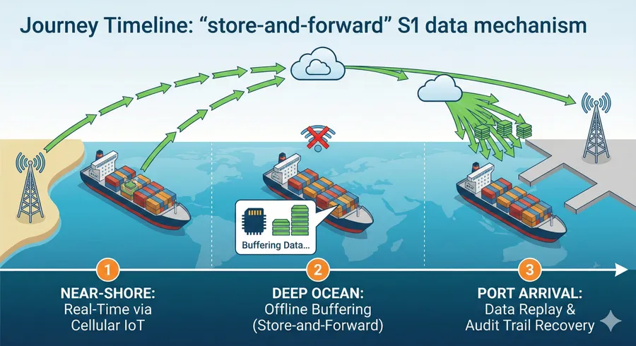
The practical reality of ocean routes. Real-time tracking is often unavailable mid-ocean. The “store-and-forward” mechanism ensures data integrity by buffering onboard and replaying the complete history upon port arrival
Connectivity planning: choose policies that match the route
The best cold chain monitoring programs treat reporting cadence as a policy:
- Baseline mode (lower frequency) during stable segments.
- Exception mode (higher frequency) during incidents or high-risk zones.
- Replay mode after offline windows.
This policy-based approach is how teams typically target long mission windows (e.g., 60+ days) without sacrificing evidence quality. See: Designing a 60+ Day Battery Mission (Reporting Strategy).
For general connectivity background, these EELink articles may help: NB-IoT Applications in Modern Logistics Asset Tracking and Cellular IoT Trends: LTE-M/NB-IoT Growth and 5G RedCap Rise.
Decision framework: when do you actually need satellite communication?
Consider satellite comm if all of the following are true:
- You require continuous, frequent updates even during long open-ocean legs.
- You cannot tolerate delayed incident visibility (buffering + replay is insufficient).
- You accept the added device/service cost and power profile.
If your primary requirement is an audit-ready record for compliance and claims, store-and-forward often provides sufficient integrity, especially when combined with event summaries (excursions, exposure, shocks).
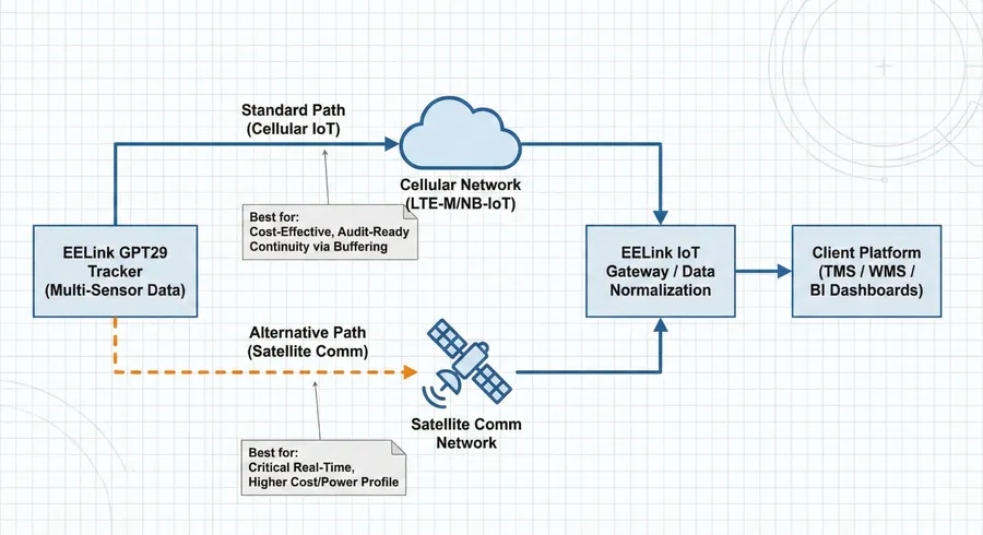
The connectivity decision framework. Most cold chain programs achieve audit-ready continuity cost-effectively via the standard Cellular IoT path with buffering. Satellite communication is typically reserved for use cases requiring critical real-time visibility in open oceans, despite the higher cost profile.
How this relates to GPT29 for overseas cold chain
GPT29 is often evaluated for in-transit monitoring where location and multi-sensor evidence are required. Product references: GPT29 Global Supply Chain Visibility Tracker and GPT29 In-Transit Monitoring Device.
In cold chain contexts, the key engineering focus is: define what “near real-time” means for your SOP, plan for offline windows, and ensure event semantics remain audit-ready. See: Temperature Excursions (Threshold + Duration).
Download the white paper
The GPT29 cold chain white paper provides the full engineering and compliance blueprint, including reporting strategy, event modeling, installation patterns, and integration guidance.
Download (PDF): GPT29 Cold Chain Tracking for Freezers — Engineering & Compliance White Paper
Contact: Contact Us or email [email protected].
FAQ
Does “BeiDou support” mean the tracker uses satellite communication?
No. BeiDou is a GNSS positioning constellation. Satellite communication refers to transmitting data via satellite networks, which is a separate capability.
Can I still have a reliable audit trail if the tracker goes offline at sea?
Yes, if the system is designed for store-and-forward with buffering and replay, and if events are modeled with clear start/end semantics.